How will this Spring hold up to the Spring of 1979?

Is two miles north of Rusty and Nona Danreuther"s place.
Ok, we have snow. We've had wind. We have drifts and everyone is talking how this winter measures up to the winter of 78/79. Comments like, "this is the most snow I've ever seen in the area", or "We're going to have so much flooding just like in 79"! To be sure thoughts need to turn to preparedness for flooding, which is hard to believe when snow is up to our eyebrows.
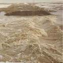
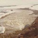
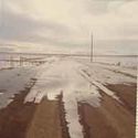
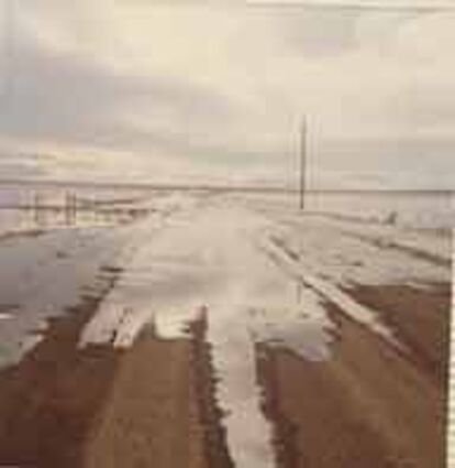
In the spring of 1979 there were numerous road outages, culverts throughout Chouteau county weren't big enough for the massive water trying to get through them. The prairie which is considered flat by too many discovered it isn't flat and water roared through the ditches and waterways, down to the roads making Lonesome Lake a real lake. People got their water crafts out and enjoyed the opportunity. Some homes on the prairie were surrounded by water, making getting to them only possible by canoe. Out southeast large rivers developed, allowing any farmer the opportunity to get into a boat and find their way to the Missouri River.

So, what do the experts say. A call to Great Falls National Weather station says, we still have less snow then we had in 78/79. Mind you they know we still might get more snow, but currently the snow is not as deep. What made the flooding in the spring of 79 was the 7 inches of rain we got, on top of the snow. in the month of March. He said even all-weather men remember 79 because the weather was extraordinary that year. "For the Montana prairie to receive ½ of its yearly moisture in one month made it an anomaly."
They have two data collection stations in the area. One is located two
miles west/northwest of Big Sandy and then the other one is located in the town of Big Sandy. According to their equipment at those sights and the equipment attached to airplanes that fly over, that measures modeled snow water equivalent, we have approximately 4-8 inches of moisture in the snow. Besides the northwest Montana, the band of snow in central Montana which starts around Big Sandy goes east to Malta and then South to Hardin and Broadus has the most snow depths in the state.
Even though we remember the flooding of 1979 here in Big Sandy it is the 2011 Missouri River floods which did the most damage along the Missouri River has it travelled down the United States. According to the research I did "The flooding was triggered by record snowfall in Montana and Wyoming along with near-record spring rainfall in central and eastern Montana. All six major dams along the Missouri River released record amounts of water to prevent overflow which led to flooding threatening several towns and cities along the river from Montana to Missouri; in particular Bismarck, North Dakota; Pierre, South Dakota; Dakota Dunes, South Dakota; South Sioux City, Nebraska, Sioux City, Iowa; Omaha, Nebraska; Council Bluffs, Iowa; Kansas City, Missouri; Jefferson City, Missouri, as well as putting many smaller towns at risk. According to the National Weather Service, in the second half of the month of May 2011, almost a year's worth of rain fell over the upper Missouri River basin. Extremely heavy rainfall in conjunction with an estimated 212 percent of normal snowpack in the Rocky Mountains contributed to this flooding event." There is considerably more snow on the ground now then there was in 2011.
the water at Easter Time in 1979, headed to Lonesome Lake.
As far as future weather indications go through April they believe we will have above normal precipitation and lower than normal temperature. Of course, that is their best scientific guess. No comments on what if the weather warms up quickly. Everyone might try and find a boat before then.